The research project examines the application of digital image analysis techniques for archaeological field documentation. We develop and apply semi-automated algorithms in order to achieve a more objective perspective on archaeological documentation and promote a standardised workflow. One overarching aim of the project is to examine quantitative possibilities to complement traditional perception-based interpretation of stratigraphy without the need of complex laboratory work.
Research
Since the introduction of airborne archaeology around one hundred years ago, the application of geoscientific remote sensing techniques for archaeological research is a steadily growing field. Within the last decades, the ongoing digitisation of archaeology strengthens cooperation with the geosciences.
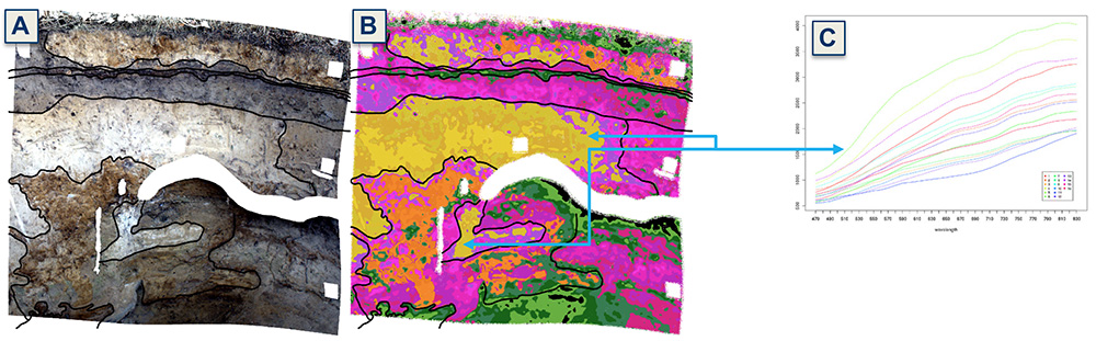
Figure 1: Idealised research concept. Images are captured in situ (A) and stratigraphic layers are delineated with respect to the classified spectral data (B); each pixel of the image contains a spectrum, characterised by the materials interaction with the available light (C) | Author: V.Haburaj
Traditional airborne hyperspectral imaging allows studies on a regional and supra-regional scale. Supporting a recent progress towards the integration of geographic information systems into actual archaeological fieldwork, this project aims at the integration of multi- and hyperspectral imaging techniques at a local level. Ongoing technological progress produces spectral measurement systems which are decreasing in size and weight and likewise might become more affordable. This development reached a point where sensors are suitable for capturing archaeological profiles and plana during an excavation with comparably low effort.
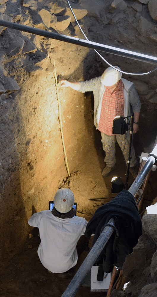
Figure 2: Fieldwork near the Great Temple of Yeha (Ethiopia), where multiple profiles were captured using a hyperspectral sensor | Photo: S.Japp
Each natural and cultural stratigraphic layer shows characteristic spectral properties (Figure 1). The acquired image data can therefore be used as an additional layer of field documentation which allows a more objective assessment of colour than conventional (subjective) methods like the Munsell soil colour chart. The semi-automated analysis of the image data additionally allows the delineation of stratigraphic layers, based on the acquired spectral data and therefore including physical measurements in contrast to traditional in situ delineation. Examining the potential of this integrative approach, the research project examines archaeological and geo-scientific profiles at multiple locations. Fieldwork and interpretation is conducted in cooperation with local experts of ongoing archaeological excavations (Figure 2). Multiple camera systems are used throughout the project to assess the importance of spectral range and resolution. The systems used are a common RGB camera and two different multi- / hyperspectral systems, capturing the visible (450 – 760 nm) and near infrared (760 – 900 nm) part of the electromagnetic spectrum.
Special attention is given to the development of an optimised and standardised workflow, based on open source software and thereby allowing for transparency and reproducibility. This kind of approach is also necessary to allow the produced results to be used as an additional layer of documentation, supporting the archaeological interpretation of recent and future researchers.
Results of the project were presented at the 5th International Landscape Archaeology Conference, September 17-20th, 2018, Newcastle and Durham:
Haburaj, Vincent, Jan Krause, Sarah Japp, Iris Gerlach, Björn Waske, and Brigitta Schütt. “Hyperspectral Imaging for Improving Stratigraphic Interpretation in Yeha, Ethiopia.”
This doctoral thesis is being written within the program “Landscape Archaeology and Architecture” (LAA) of the Berlin Graduate School of Ancient Studies (BerGSAS).